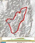
8.8 mi :: 5 hr
Just up the canyon from our campsite, someone has dug a small well. After breakfast I wander up with Jezebel and fill her water bottle. There are some tadpoles swimming in it, but she doesn’t mind. You could certainly filter this water. There are probably mainy spots in the canyon where water is just below the surface. Ann and I still have several liters from yesterday, though, so we don’t have to try it.
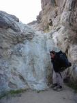
Dead Horse canyon continues east for a while before turning north to meet Marble Canyon. Walking into the sun, we hit another dry fall that is more difficult to descent than the ice falls. Ann passes her pack down to me before sticking her feet to the dirty, sloping holds.
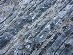
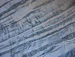
The rock is the star of the day today. As we draw closer to Marble, the variety increases. The number of colors in the rock layers multiplies.
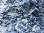
The variety of shapes grows as well. I wonder if the spheres in this geometrical arrangement are bubbles in cooled magma that later filled with some other kind of rock? We lament our geological ignorance.
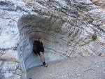
There is a large cairn and a trail that disappears over a small hill where Marble Canyon joins Dead Horse. Ann wonders if the trail might skirt the dry falls we climbed down. We explore a little ways up Marble Canyon, then head down. It doesn’t take long for the classic, banded marble to show up in large formations.
The canyon squeezes in, then opens up again in intervals. Each narrow is more impressive than the last one. We meet an older couple, the man walking in cowboy boots, who tell us the best is yet to come.
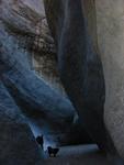
Indeed, we soon enter a deep marble slot that is almost like a cave, with just a narrow crack of light above. The walls are dark marble, scarred by torrents of water as if they were blasted by jet engines. The floor is dark, cool, and still.
We’re starting to tire, and take a lunch break just before reaching the end of the Marble Canyon road. From there we push quickly back to the car. We still have water left, but feel like we drank our fill on this hike.
7 responses to “Cottonwood-Marble Canyon Loop Day 3”
the second to last pic is classic. i’d like to get a full version of that.
sounds like yer hike was good and uneventful. did you use your alcohol stove?
the climbing in Marble would be insane. what a great place.
eh.. i come up with 26.4 miles. i thought anne said you guys did ~30 miles??
so, 26 is what the book says on it. looks like yer gps is doing gooood.
We didn’t use my stove – I still haven’t made a pot stand for it.
I think the climbing in Marble would mostly be too hard for me, but I did see a few classic-looking lines that might be in my reach.
I’m adding up mileage from my DeLorme mapping software. I did get the last day wrong, but it adds up to 27 for the whole loop. I think this is too short, partly due to a lack of resolution in the map data. I would like to compare it with a GPS mileage (which also comes up short due to reception hiccups & slow sampling rate, but is another guess). But to do that you have to leave the GPS receiver on all the time, which eats up batteries.
emmmmmmm batteries. i am so hungy i could eat a battery.
well, it’s not that important. still, it’d be nice to know EXACTLY how long the loop is.
It’s always an approximation. I’m guessing that my small-scale map data is +5%/-10% for hikes. The 7.5′ quad data would probably give more like +2%/-5%. I think the GPS tracking would about the same.
Hi there… found your site while seaching for info on Dead Horse Canyon – the canyon we never found (I don’t think). We set out on Thursday 8.3 miles from Stovepipe Wells… hiked up Cottonwood Canyon wash and a bit into the canyon itself (slept about 4 miles past the ampitheater). There was *plenty* of water from about 3 miles above the ampitheater all the way to the valley at the top of the Cottonwood Canyon.
We spent the late afternoon on Day 2 looking for the “unmarked trail” crossing a “low point on the ridge” to Dead Horse Canyon (which by the way, is marked as a trail on the National Geo. topo map). At one point, I dropped my pack and left my friends to scout for the trail at the lowest point in sight… I went all the way up and over a bit – no sign of humans having been there. In retrospect, it was probably where we should have gone. I returned to the other two, it was getting dark, so we slept 2-3 miles above the Keeler sign post.
Day 3 we headed up a different low point in the ridge much further up the valley (?) and saw some footprints, which gave us a sense of (false) hope. We followed the path of least resistance up and up and then down and down where we met a little flowing spring/stream. We followed the water down and down and down a steep canyon/ravine (?). It was rough going and we made our own trail as we went back and forth across the water depending on which side was less steep and/or offered solid foot/hand holds. Spent at least 1.5 hours doing this. Then one of my 2 friends dislocated her shoulder… I put it back in.
We continued and our path leveled out a bit – more false hope. Around the next bend we saw what may have been another mile or two (hard to tell with the bends and because we weren’t sure *exactly* where we were on the map) of the same (but more formidable looking) before us. We decided to abort the mission (not knowing for sure if were were in Dead Horse Canyon and if we weren’t, whether we would end up in Marble if we kept on).
We climbed on all fours (one of us on just 3) out…. took nearly 2 hours… scree the whole way… hellish… I battled against my fear of heights, it was so steep – had to stop to catch our breath every 30 feet or so (and we’re all fit 30-somethings). Sharing the weight of the third’s pack (because of her shoulder) was tough too.
We made it to the top – saw the peak that sits on the east side of the valley to the north of Cottonwood Springs… headed over more ridges and back down as gradually as possible. We’d set out at 6AM; it was noon before we reached the sandy shores of the Cottonwood spring (?) and headed back down Cottonwood Canyon.
I’d guess we hiked about 20 miles that day… I left my friends at the ampitheater (Cottonwood wash) and jogged back to the car (blisters and all) to come back for them. A couple of helpful souls gave me a lift and cut the 6.2 mile journey down to less than 4 miles on my feet. We missed our flight out of Vegas…
Where the HELL do you cross to get to Dead Horse Canyon? I guess it’s our fault for going without a GPS and more maps… I’d printed info off the NPS site, read various reports of the loop, and had a topo map… My map reading skills are pretty solid. I never doubted where we were (within a mile or so). Someday, I’ll make it to Marble Canyon via Dead Horse Canyon (next time we’ll park at the Cottonwood/Marble sign!).
Thanks for listening… needed to get it out to someone who had been there!
Hi Eileen –
I feel your pain! We could easily have suffered such a fate. It was Ann’s insistence on bringing 7.5′ USGS maps that pulled us through. Our GPS was helpful, but I hadn’t yet learned to use it properly and all my readings were a little off (this really bit us later on the Continental Divide Trail). If you bring a GPS, make sure you can find your position in a verifiable place first!
I don’t think we ever found the ‘unmarked pass’, although we did go over an unmarked pass. On the large scale topo, it was clear that going over the pass at the very end of Cottonwood Canyon was the safest bet for getting into Dead Horse. There was no guarantee we could get down it once there, and it was heavy-duty bushwacking! We crawled on all fours through many thickets, climbed down an ice fall, and switched from one steep canyon wall to the other many times.
I agree that this is a much more difficult hike than the nice hand-outs at the park office make it out to be. The directions are a farce. I do think that it would take an enormous mistake for you to NOT wind up either back in Cottonwood or in Dead Horse, but it’s very likely that you’ll wind up on tough, dangerous terrain.
On the other hand, what an awesome hike! I’ll never forget it. It’s worth another trip to see Marble Canyon, even if you just hike up it and turn around.