I’ll start with some facts about the trip with comments to follow.
In my planning I came across Romain Wacziarg’s June 2002 trip report, which is not too far short of a full guide to the route. If you want pictures and other practical information that I don’t have :cry:, check it out.
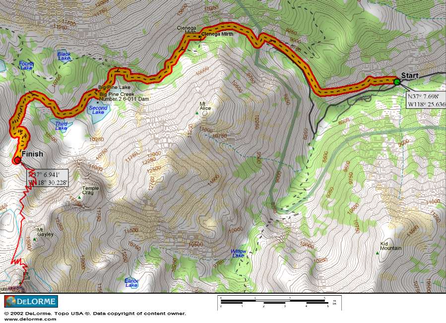
Location: The trailhead is near the end of Glacier Lodge Road, which starts on Crocker Ave in Big Pine between the two gas stations on highway 395. The parking lot is at about 7500 ft, and though we didn’t fully clean out the car to discourage marauding bears, others there did. Some even left some beer out underneath the car, which I had to resist the urge to plunder myself.
Gear: We carried a 60-meter rope, all but the biggest cam on my rack, a dozen draws, helmets, crampons, ice axes, and other usual climbing gear (rock shoes, harnesses, slings, etc) in addition to our camping gear. We didn’t weigh the packs, but I’m guessing they were 40-50 lbs apiece. The crampons & axe were necessary for the morning traverse of the Palisade glacier. I could have done without one of my two sets of nuts, my small aliens, small hexes, and a few draws. The climbing is not very continuous, and I didn’t end up using as much protection as I thought I might. I did use my 1.5″+ hexes, and having an assortment of cams was nice for anchors. We did use the whole 60m rope on one pitch, but would have been fine with a 50m too.
Trail Conditions: The trail is really nicely graded. We started at 9:30 am on June 6 at the 7500 ft trailhead, and by 5:00 pm had reached a nice bivy spot at 11,500 ft, above Sam Mack meadows. That’s 4,000 feet of climbing in about 8 miles. Some of our party took two days to go in, one to Third Lake at 10,000 ft, then up to Gayley High Camp at 12,000 ft the second day. We starting having to go through snow at 10,500 ft, and left the trail to stick to the rocks several times.
Our Party: Me & my fiancee Ann, Roy Boswell & Marc Tranchemontagne, Mike Franklin & Walter Runkle.
Day 1
Some maps show the road continuing a little way up the north fork of Big Pine Creek, which is where I originally thought the trailhead was. Because of this I was thinking we’d be going up the same valley the entire time, and when the North Fork came plunging in on the right I nearly tried to cross it and continue up the South Fork. Ann was dubious, and luckily we quickly ran into some friendly day hikers who set us straight. I had wanted to check the map, but was too lazy to dig it out. Lesson learned, I hope, though I should have learned it long ago!
First, Second, and Third lakes are enchanting as you pass them, their deep blue waters nestled among trees and cliffs, beckoning for an icy dip. The trail stays a ways above them however, and we were on a schedule, so we resisted.
Shortly after the Glacier Trail turnoff the postholing began. I think this was Ann’s introduction to postholing, and she cheerfully followed us as we took turns yelping when the soft snow swallowed a leg whole. She was dubious once again, however, when we reached Sam Mack meadows and faced a creek crossing on wet rocks. Mike graciously gave her a hand, and she made it across without incident. It was about 3 pm now, and the sky had clouded over.
We left the trail before long to avoid more snow, and soon came to a nice bivy spot with some flat areas and flowing water. We were being pelted by some snow in a cold wind. Walter proposed we stay, and we all agreed. It was 5 pm, and we didn’t feel like climbing another 500 feet to a less hospitable spot, where we presumed Roy and Marc were camped.
As we made camp and cooked the sky cleared up. The shells & cheese I packed for dinner went down mighty quick under glowing twilit peaks, and we wondered if we had enough food to get us through another two tough days.
The night was strangely warm. I woke up sweating a few times and peeled off some clothes to the sound of an occasional climber fart rising past the gently glowing snowfields and into the deep starry sky.
Day 2
We heard Walter heating water at 4:45 am, and rousted ourselves. The eastern horizon was already bright orange, and I knew immediately we were running a little late. But we didn’t rush through breakfast, Ann had her tea (heaven help me if I ever deprive her of it), and we managed to set off by 6. An hour later we reached the Gayley High Camp via an improvised route and found Roy and Marc at the edge of the Palisade Glacier, futzing with their crampons. We greeted boistrously and joined in the gear futzing. Walter was the only one who had used crampons before, so he gave us all a little advice and a self-arrest demonstration. Soon we were all happily crunching over the glacier towards “the gap” below Mt Sill. Having negotiated such snowfields in running shoes on the PCT, the crampons felt marvelous, and it was great watching Ann dance over her first glacier gracefully with proper gear. I thought she might be spared some of the trauma snow travel had dished out to me, but alas it was not to be.
It was after 9 when we all reached the L-shaped snow field around 13,000 feet. The snow had been softened in the sun, and we could see the beginning of the route where the arete leveled off a few hundred feet higher, then rose steeply again. There was some mumbling about the lateness and yesterday’s afternoon storms, but we all geared up and set off anyway. We postholed to our thighs in the sloppy snow, and headed immediately for the rocks at the base of the arete.
We were scrambling up the lower arete when Roy yelled up from the snowfield that he and Marc were turning back. He was concerned about afternoon weather and felt too worn out to do the route quickly. Ann felt the same way, and after some quiet discussion she yelled down an offer to go down with Roy and let Marc come up with me. Marc tried to talk her out of it, but she had decided. I resisted the urge to persuade her myself, because I wanted to let her develop her own mountain judgement. In the end we have to be able to make our own decisions up there, and take responsibility for them. I watched her go down with a little remorse, then tried to shift my attention to the arete.
The scramble to the level part of the arete was a good warm up. The moves felt secure, yet took enough effort and attention to make one aware of the altitude. I also paid attention to Marc, who seemed to have a touch of apprehension but handled it well. We were soon roping up behind Mike and Walter, just below the spot where the arete steepens noticably and the real climbing begins.
We used about 50 meters of rope on the first pitch, mostly climbing over large blocks. I felt a little lightheaded but otherwise solid, protecting the two steepest parts, joining Mike at a roomy belay platform. Marc followed easily, but wasn’t sure if he felt ready to do any leading. Coming straight from Florida, I was impressed that he was able to climb at all at this altitude.
Walter set his belay after about 35 meters on the second pitch. The climbing got a little better, but the effort made me a tiny bit queasy. As I set my belay Mike let out a little yell as he passed the crux “step around move” on the third pitch, and I thought about how awful it would be to throw up while climbing. But I put those thoughts aside, breathed deep, and belayed Marc up.
I took some time figuring out how to protect the “step around,” ending up with a big hex at my feet. It’s an exciting little move, followed by a good dihedral and a steep little jam crack. Definitely the classic part of the climb. Then the angle breaks and you can almost walk to the base of the next pitch for a total of about 45 meters.
The last two pitches start with a slightly awkward wide crack, then continue over fairly easy big blocks. The rock had all been primo so far, especially for an alpine route. Here there were some loose rocks, but they were easily avoided. We stretched pitch 4 out to nearly the full 60 meters, leaving one short 20 meter pitch to the top. Marc and I joined Mike and Walter at the summit at 1:15 pm under beautiful, mostly clear skies.
We took in the view at 14,162 feet for a while, picking out Mt. Whitney to the south and Banner & Ritter to the north. When we started down the northwest ridge Walter lead the way, being the only one who had done it before. We debated a bit about where to climb down and double back towards the notch above the L-shaped snowfield, but finally spotted a large cairn and the “15-foot high leaning rock” that mark the descent. Just below that was a rappel station, which we elected to use rather than climbing down the steepest 4th-class section. This brought us easily to the ledges which traverse over to the notch.
I was the first to set out on the snowfield, thinking I would plunge-step down since I didn’t have snow pants for glissading. I soon gave up any illusion of staying dry though, sat down, and half-swam down in a river of slush. Walter was next, timing his glissade at 3 minutes.
The rest of the descent was straightforward, if tiring in the softened snow. The only part that concerned me was a water-bottle left in the steep upper reaches of the Palisade Glacier. Ann must have dropped it, and I hoped it wasn’t in a fall.
When we joined Ann & Roy at the high camp I got the full story. On the way down Roy decided to show Ann how to glissade. He explained it and then went down himself. He said the snow was a bit hard, and he had to lever his brake with his body, but he came to a stop when he wanted. Ann started twice and immediately self-arrested each time (probably where she lost a bottle). The third time she lost hold of her ice axe and went hurdling down the glacier, right on past Roy. The axe was still on it’s leash, banging around behind her and thwacking her helmet. As the slope decreased she managed to get control of it and come to a stop before she was plunged into the icy glacial tarn. I was thankful that she was unhurt and had a good helmet, and also that I didn’t have to helplessy witness her careening out of control down the glacier. This event made me realize vividly how having someone you dearly love along on an adventure changes the whole experience. Disasters are even less pleasant to contemplate, while sharing the highs brings them to a new level of bliss.
It was unexpectedly tough getting back to our bivy site, with a light rain wetting the rock fields, a slow route, and Ann still feeling unsettled by her ride. But we made it, I managed to dump only a portion of our hot dinner on the ground, and we settled into bed filled with a gratifying exhaustion.
Day 3
It felt like a leisurely exit day. We lingered in camp a while after Mike and Walter started down, then found our way back to the trailhead in about five hours. We got some honest thunder showers around 2 pm, and were happy to enjoy them in lower climes than we would have yesterday. We met an enthusiastic Swedish hiker headed for the glacier, who captivated Ann with the idea of a distance hike in Sweden. So the end of one outing only begs for the beginning of others…
8 responses to “Mt. Sill Swiss Arete Trip Report”
yer buddy romain’s pics suck. they are all small.
so, a SMALL rack with medium sized pieces is the trick? i would like to do the route sometime, go it as light as possible. sounds like hexes are good.
thanx for the beta…
foto$lut
DUBIOUS DUBIOUS DUBIOUS
THAT’S ME
Me too! I remember Pete telling how to cross a swift river: walk 1/4 mile upstream, get in, and while you’re swooshing downstream kick towards the other side whenever your feet hit the bottom. DUBIOUS I was. But, like you, I did it anyway 🙂
CHRIST you’re getting into this. dancing and farting and twilight and ALAS!
I was visiting the Cyber Hobo and read a very wonderful, and very human trip report on the adventure to Mt. Sill. Of course I had to link to the trip report of Romain Wacziarg. To my delight, my then 17 year old son Sean and I were mentioned in the first paragraph (and latter as well) as the “rude climbers” who violated “Sierra etiquitte”. I remember like it was yesterday, though it was just one year. Sean and I arrived on the morraine above Sam Mack Meadow. Sean and I were tired because we had done the approach in a day, not two days, and no naps. Not wanting to camp on the glacier we selected one of the few sites a reasonable distance from another party. Naturally we were friendly with the same party but were patronizingly advised to, essentially, move on since we were too close to their spot. My family and I were laughing about this tonight over dinner tonight when my 20 year old daughter, with whom I have climbed Mt. Conness via the West Rib, commented that “a Wilderness Permit does not convey title”. Anyway, my Son was the first to detect our estwhile neighbor’s French accent. Sean is very familiar with the arrogant Parisian demenor having visited France, and Paris twice. As I sipped a California Beaulieu Cabernet from Costco, I explored Monsieur Wacziarg’s web site, imagine, what accomplishments, both academic and alpine, and he is from France as well. At least that’s where he tells us he was educated. Oh, but back to Sean and my attempt on the U-Notch. We easily past the burg, but found the snow higher on the slope wet and we were postholing. My own alpine experience told me that to continue was unsafe. The late Spring snow on the notch appeared unconsolidated and was at risk of sliding. In fact I was talking with Doug Robinson last April and he recalled that the U-Notch had slide just a week latter. Well, see you arround the Sierra Mr. Wacziarg, unless yuor napping, and in the mean time, GO BRUINS!
Nice TR.
My photos are small on the TR page but if you click on them you get a bigger version…
Oh, and I just read the last entry. Yes the French are arrogant and that’s part of the reason I emigrated. But I’ll maintain the Sierra is big and setting camp right above another party is poor etiquette. No hard feelings though.
Well, if you can still pay me a complement after that commentary, you’re alright with me. Thanks for posting.